Body text
FTIR measurements at Porto Velho, Brazil
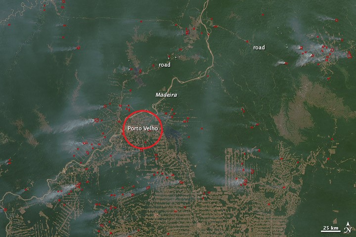
Porto Velho is located in Rondônia, the Brazilian state where deforestation has been the most intensive in the last decades (Fig. 2). The deforestation increases the occurrence of anthropogenic fires, as well as the risk of wildfires.
The FTIR technique allows to simultaneously measure many atmospheric species of biogenic and biomass burning origin, such as:
- carbon monoxide (CO)
- ethane (C2H6)
- acetylene (C2H2)
- formaldehyde (HCHO)
This is a remote-sensing technique, which means that we do not measure the concentration of the species at the Earth surface, but the amount of the species in a column of the atmosphere (from the ground to an altitude of about 20km for the tropospheric gases). Satellites measure a similar quantity which makes the FTIR measurements perfectly suited to verify the quality (accuracy and precision) of the satellite measurements.
Comparison with model data to improve our knowledge on emissions
We compare the FTIR time-series measurements to column data modeled with the BIRA-IASB IMAGES model to evaluate the model inputs, such as:
- anthropogenic or biogenic emission databases
- wind transport
- chemical reactions
During the dry season (July-October), when fire events reach their maximum, the model data agree very well with the observations on the expected timing of the maximum (Fig. 3), but systematically overestimate the observed values, pointing to a likely overestimation of burnt biomass in the fire database used in the model.
During the wet season (February-June), the model is in very good agreement with the observations for HCHO, while it underestimates C2H2. This suggests the existence of a missing or misrepresented source in the anthropogenic database used in the model, possibly related to biofuel consumption.