


Royal Belgian Institute for Space AeronomyPhysics and chemistry of the atmosphere of the Earth and other planets, and of outer space.
Impact of pollutants on air quality and climate | 2023-2024
Model simulations performed at BIRA-IASB to explain large, unidentified source of formic acid in the Earth's atmosphere.
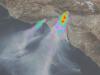
BIRA-IASB is developing a system to monitor natural hazards (volcanic plumes and sandstorms) at the global scale from a geostationary constellation.
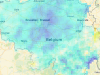
LEGO-4-AQ integrates Sentinel-5P satellite observations with in-situ reference measurements to track NO2 concentrations near the surface.
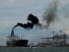
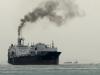
SEMPAS aims at quantifying and monitoring ship emissions in the Belgian North Sea.
To develop harmonised long-term data records of six atmospheric trace gases that are precursors of ozone and aerosol Essential Climate Variables (ECVs).
BIRA-IASB has continued to develop and interpret improved HONO retrievals from satellites.
Observations of volatile organic compounds that influence air quality and climate to verify the quality of satellite measurements.
To improve mutual consistency of the satellite data for the second TOAR assessment, BIRA-IASB has undertaken the vertical harmonisation of 16 key satellite global datasets.
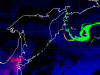
New method to assess the impact of the Red Sea shipping crisis on NO2 levels along major shipping routes between Asia, Middle East and Europe.
Terrascope ecosystem to browse satellite data. BIRA-IASB has teamed-up with VITO to add products based on Sentinel-5P data.
To intercompare various remote-sensing instruments measuring pollutants and contribute to further develop the reference systems needed for satellite validation.
Recurrent airborne campaigns using the SWING hyperspectral imager map the NO2 distribution, aligned with TROPOMI overpasses.

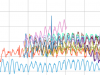
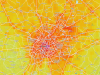
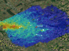
New research reveals the main sources of greenhouse gases near Beijing using advanced ground-based measurements and an atmospheric transport model.